Sunday, August 9, 2020

Day 7 - Rookie Mistake

Our original plan had been an early wake up so we could get to the tire shop before it opened, but having been lulled into a wonderful slumber with air conditioning, a comfy bed and a flush toilet, we lollygagged for a few minutes too long, and by the time we got to the tire shop at 8:05, we were third in line.  We chatted with another couple from New Hampshire (Chris & Lelah) while they were getting their tire repaired as they, too, had blown it on Hole in the Tire Road yesterday.  We left our tire and went to eat breakfast and when we came back to the shop an hour later, there were four more cars in line with blown out tires – clearly, that road keeps these guys in business.  They couldn’t fix our tire – something had carved a z-shaped gash in the tread and it was DOA.  Luckily, they had a used tire that fit our car and for a mere $57, we were on our way.

The hike we had planned to do, Big Horn Slot Canyon, has two different entry points – one from the bottom from HITRR and one from the top from Old Sheffield Road.  We had heard that the Old Sheffield Road route might be a little shorter, and since we lost 2 hours in tire repairs and the day was heating up quickly, we opted for the Southern Route.  The drive on Old Sheffield’s rocky unpaved road was only 3 miles from the main road, and en route, we saw some amazing potential camp sites for the night.

We pulled into the “parking area”, which was a tiny grassy area the width of two cars.  There was one car already there, so we took the second spot and started on our hike.  The path was easy to follow – it was mostly through a dry riverbed (The Harris Wash) and we were able to follow the footprints of the two people who were ahead of us.  

The hike was about 2.5 miles to the slot canyon and it was mostly deep sand (like on a beach) and rocks.  We tried to stay on the rocks as much as possible, but the vast majority was sand.  We played tracker and got excited every time we saw footsteps since that meant we were going in the right direction.  Truth be told, getting lost while following a riverbed is difficult, but I wouldn’t put it past us.  The sun was in full force and it was hot out, but that did not deter us.  Nor did coming across a 60’ drop in the riverbed.  Yes, it was literally a 60’ drop.  The Google stuff I read said that this was a “moderately easy” hike and I’m thinking – a 60’ cliff is a moderately easy hike?  There was some swearing in there, too.  Google also said that there was an easy way around the drop to the left.  The easy way around was like a 70-degree angle instead of a 90-degree angle of mostly slick rock.

Damon went first and I followed crab walking down on my butt.  I’m too old for this shit.  No, I’m not – it was kind of fun once I got to the bottom.  


Eventually we got to the mouth of the slot canyon with another big drop, but this time it was skinny, and we weren’t sure we could get back up, so we started exploring the top of the slot.  

Hard to tell, but that is about a 12-15' drop to the bottom

Looking down - we didn't think we could get back up without ropes

Side note – the primary reason we had initially chosen the HITRR start point was because as you approached from that direction, you went through the best/easy slots and then they got progressively harder until you had to turn back because it got too technical and required climbing skills and ropes.  Well, that would be where we popped into the slot and we are most definitely not technical climbers.

We investigated around and popped in and out for part of it and eventually we heard voices.  We were so excited to meet “the footprints” that we had been following.  Go figure – it was Chris and Lelah from the tire repair shop!  They said that they had been exploring in and out of the slots farther up like us, but determined it was too technical and didn’t get in very far.  Sadly, that meant the end of this exploratory endeavor and after hunkering in a slot crevasse for a snack, we headed back. 


Now let’s talk about what the Utah dessert feels like around noon when there is no shade and you are walking in ankle deep sand.  It is pure flipping torture.  We were sucking down water like crazy and stopping whenever we could find a bush or scrap of shade.  It was brutal.  There was a point where I was ready to lay down and declare “save yourself, just leave me here to die”, but we soldiered on.  When we came to that 60’ wall and had to climb up, I had some crazy burst of energy and while Damon was still mapping his route up the slick rock, I ran up it and he was like WTF??? 

At one point, we stopped for a water break and I kept telling Damon to open the water flow and in the most amateur hiking move ever, we realized we had run out of water.  In our Kaibab Hike, we had gone through half the amount of water in the same distance.  We got very lucky in that we were only about 5-10 minutes from the car, but it was such a rookie mistake, we were horrified.  We got back to the car and each drank a huge bottle of water, followed by a huge bottle of Gatorade, followed by more water.  My fitbit registered an average heart rate of 124 bpm on the way back – we were walking!  Probably one of the hottest hikes I’ve ever done.  No pictures from the way back, but one bonus scenery shot from the way out while we were still smiling.

Post walk, we drove to our Escalante Oasis, aka, the Escalante Visitor Center, which although closed, does offer a cell signal, clean air-conditioned bathrooms, and some nice shaded benches.  We parked in the lot, opened the car windows, and promptly fell asleep – both of us.  After a quick nap, we put together our picnic and had lunch and sat there for about 2 hours while I worked on the blog 😊

Around 4:30 or so, we went back to Old Sheffield Road to find the campsite we had identified earlier and set up camp.  It was Damon’s dream site – no one anywhere around, the view was spectacular, and we had enough time to just hang out, relax, and stare at nature.  


Around 7 we started dinner and again, we were aggravated by a pesky bee, which, was a yellow jacket (wasp family, mean little buggers, can sting multiple times).  Damon killed it just as we plated dinner and within about 20 seconds, we had about 5-10 more yellow jackets swarming our food.  We tried killing them, got a few, but more just kept coming, so we ran into the car and had a lovely dinner sitting in the front seat of the car.  Once the food was gone, the bees had no further use of us and disappeared.  I had no idea yellow jackets like chicken and peppers as much as they seem to like tacos!

Went to sleep around 10 with a plan to get up early so we could start our next hike before the crazy heat kicked in.

Sunset and our fancy tent lights


Saturday, August 8, 2020

Day 6 - Hole in the Tire Road

Woke up, made oatmeal and coffee with a French press (we fancy) and after a leisurely breakfast, we packed everything up and made the drive to Grand Staircase Escalante National Monument, where we plan to spend the next few days exploring slot canyons.  Our first hike today was the Willis Creek Slot Canyon.  The drive in was on a dirt/gravel/sand road – Damon loves these because he thinks it is not fair to have a 4Runner in the city and sometimes they need to have fun, so Richard (our car), got to play in the dirt on our way to the trail-head. 

We had the option to hike 2.5 miles or 4.5 miles.  Given that we were still a little beat up from yesterday AND the fact that it was a balmy 90+ degrees, we did the shorter hike.

If you’ve never hiked a slot canyon, they are my favorite – usually following a current or former riverbed, they tend to get really narrow and windy and the colors and patterns left behind are just amazing to look at.  Plus, they are usually narrow enough to have shade and a nice breeze.  This hike had a tiny stream that you just hopped over back and forth as the path followed alongside. 


The slot canyons were short, but there were maybe 4-5 different ones offering some nice reprieve from the sun.  Overall an easy hike.  After the hike, we made the hour drive to the town of Escalante where we were going to go on another 2 mile hike in the Escalante Petrified Forest, but we got super lazy and decided to find a campsite and just relax.  That didn’t happen.

Random Scenery Shot in Escalante

There is a road out of Escalante called “The Hole in the Rock Road” – it is about 55 miles long and is all gravel – and it is in Grand Staircase Escalante, so in theory, we can camp anywhere.  We found the trail-head for our first hike tomorrow and started looking for a place nearby to set up for the night.  And that is where we got the flat tire.  We have no clue what we rolled over or how it happened, but that sucker was flat as a pancake.  

Temperature reading – 97 degrees, no shade, stuck in the middle of a dusty road.  Damon said I could sit in the car with the AC on and I very forcefully offered to assist and do my part.  Ha ha, no I didn’t.  I sat in the car until I was bored (3 minutes) and then took pictures for posterity.  I tried to help, but reality is that I have no clue how to change a tire.  I unloaded every single thing (we do not travel light) from the back of the car to access the spare tire, which, of course, turned out to be underneath the car meaning literally nothing had to be removed.  Oops.  I think Damon just wanted to keep me busy. 
Everything out of the car for no reason :(

My next assigned job was to read the manual and look up YouTube videos because we couldn’t figure out how to unlock the spare.  Again, for what little internet we’ve had the past two days, we lucked out with enough service to watch the perfect video.  It took nearly 2 hours, but for once, everything worked in our favor and we (Damon) got it done. 

Big shout out to the 10 our so cars that slowed down to check on us and make sure we were okay.  And may two cars that sped by us almost running over Damon while kicking up a massive plume of dust that covered everything be hexed with their own flat tire one day.

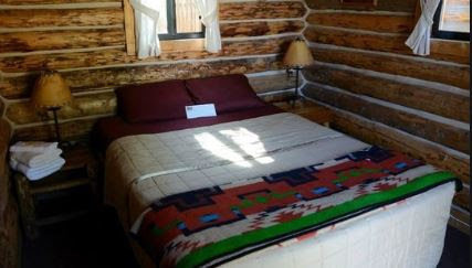
By the time we repacked everything, it was after 7pm and neither of us wanted to set up camp.  So, back to the town of Escalante for dinner.  We tried to find an actual campground so Damon could shower – 2 hours laying in dirt and sweat makes one a dirty unhappy camper.  We found a place that had campsites and little cabins but when we looked at the campsites, we quickly realized they would not work as you could not drive a car to them.  So, we are now laying in a nice comfy bed in an air-conditioned cabin.  We are, however, roughing it because the toilet and showers are a solid 20’ away.  Not sure how I’ve managed to stay indoors for 4 of our 6 “camping nights” so far, but lets hope this trend continues!


Escalante Outfitters - Cozy Cabin


Day 5 - That's Where We Want to Go - Way Down in Coconino

Today started with a quick side trip to the Lake Powell Dam.  My only comment upon seeing the dam was a long extended “Daaaamn to which Damon gave me an exasperated sigh.  

As is typical, my sense of humor generally only exists to make me happy.  

One downside to not camping and eating most of our meals out is that a lot of the food we brought was, let’s say, at the end of its useful life and was starting to get a little stinky (imagine broccoli in a hot car for a few days).  So, we dumped all of our meat and most of our veges, made a quick stop at Safeway to re-stock.  I think I’m running out of Hyatts and will eventually have to rough it.

It took about 2 ½ hours to get to the North Rim.  We crossed the Colorado River at the eastern most side of the Grand Canon at the Indian Bridge.

We chose the North Rim versus the more popular South Rim for two reasons – first, we wanted to avoid crowds as much as possible.  Based on my last experience at the South Rim (27 years ago), it was crowded and given the fact that everyone is hitting the road this summer, the South Rim was a potential Covid petri dish we wanted to avoid.  Second reason was that the North Rim was just closer to the rest of our road trip route.  The road to the North Rim was empty (good sign) and we passed through some really interesting scenery from pine forests to a 5-10 mile stretch that was recovering from a fire in 2006 to huge grassy plains – not what we were expecting.  

The North Rim does not have any of the fanfare of the South Rim – there is a little visitor center and a bunch of cabins and not a whole lot more. 

The first trail we found was the Bright Angel Rim trail which gave us our first stunning overlook of the Grand Canyon. 

Since it was the main scenic trail closest to the visitor center and because the trail was super short, it is the one everyone went to.  We got our view and went to go find a more challenging hike that would have fewer people.  Enter the North Kaibab Trail.  This trail is the one that leads to the bottom of the Canyon and then the South Kaibab Trail leads back up to the top of the South Rim.  There are various “turnaround” points on the North Kaibab.  Obviously, you can turn around anywhere, but there are a few notable viewpoints and some that have water or toilets, so those have mile markers attached.

Before heading onto the Kaibab trail, there are warnings EVERYWHERE – at the trail head, the visitor’s center, the maps, etc.  Every warning shows the difficulty level of getting to each turnaround point, estimated round trip times, heat warnings (it gets MUCH hotter as you go down), water warnings, etc.  Basically, don’t be a dumb-ass.  We decided to go to the 2-mile turnaround point called the Supai Tunnel which had water access and pit toilets.  It was the first option in the “difficult” range but still fine for a half-day hike.  Above all, the warnings state that you should, under no circumstances, attempt to go to the bottom and back in one day (this is important later).  Oh, also, the start of the trail is at about 8,000 feet – so awesome for us flatlanders.

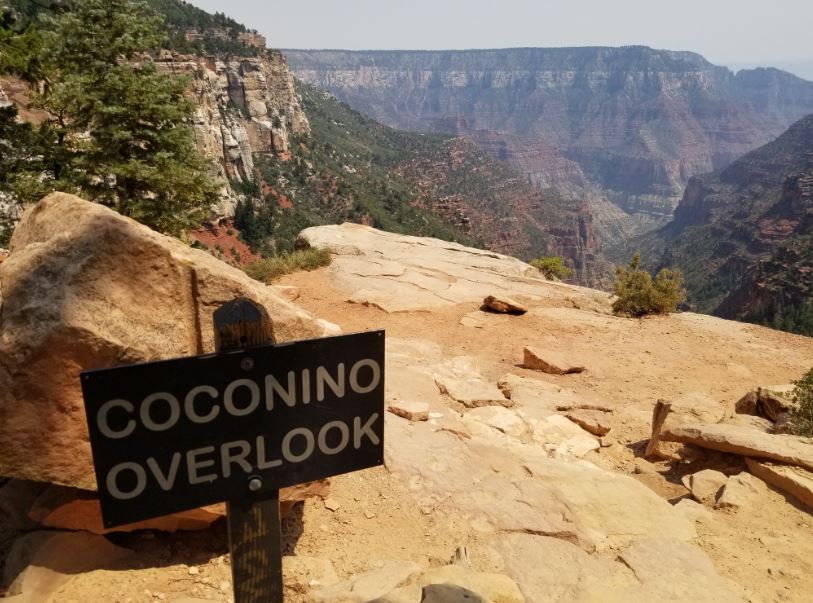
We loaded up on water and sunscreen and headed out around 1:30pm.  Every step we took was  downhill and at a decent downward grade – which is great until you start thinking about what it will take to get back up.  The trail was mostly sand and rocks and the color of the sand changed the farther down we went, matching the different layers of rock.  There was no level ground, just straight down.  We hit the first overlook at the ¾ mile mark called Coconino (or as I referred to it, “Kokomo”, because that is a happy place.)  


We had been sheltered by trees as we wound down into the canyon so didn’t get much of a view, but that changed when we hit Coconino, which not only opened up for a great view of the canyon, but also created a perfect wind tunnel for cooling down.  

Airing out in nature's AC

After a short visit, we soldiered on to find the Tunnel.  The Kaibab trail is also a mule trail, and as we closed in on the Tunnel overlook, we got passed by two groups of mule riders heading back up.  As you can imagine, Mules need to relieve themselves, so we had the pleasure of side-stepping mule poop and pee on a regular basis.  To say that the smell of fresh mule pee is blinding is an understatement.  We spent a few minutes at the Tunnel area, obviously I had to check out the toilet and then figure out how many people and how long it must have taken to build it and who hauls all the junk out, etc.  Anything to delay the inevitable walk back up.

Bottom part storage; top part pit toilets

The infamous Tunnel

We had only seen a handful of people on the way down (more on them later), so we were pretty sure that we were the last ones on the trail unless people had gone down farther and were on their way up behind us.  The way up sucked huge.  Hard to say if it was my fitness level or the altitude, but that hike back up kicked my butt.  Luckily, the weather gods were on our side and while hot, it was not crazy hot and the canyon shaded us most of the way back up.  Unluckily, following behind 20 mules while heavily sucking wind was not great.  By the time we were in the last half mile, I was counting 100 steps and stopping.  Damon says he never felt bad.  Jerk.

So for a relatively fit middle aged woman still sporting a few extra Covid pounds, I thought it was a moderately difficult, but doable, hike.  I would have been very proud but for 2 groups we passed on the hike.  Number one – 2 men who we had first seen at the top of the canyon when we began our hike and then bumped into later when they stopped for water – they must have passed us when we were at Coconino.  These two were on their way BACK DOWN having started at the SOUTH freaking rim at 5am.  They had already RUN down the south rim, crossed the river, run up the North Rim and were on their way back down.  Roughly 40 miles round trip and they barely seemed winded.  Remember, you are not supposed to do one rim and back in one day and these guys were doing both.  Insane.

The second group we passed was shortly before we hit the Tunnel and they were on their way back up.  This was a family of 7 Hasidic Jews – parents and five kids ranging in age between roughly 8-15, Three boys and two girls.  The boys and dad were wearing long black slacks and long-sleeve white button down shirts.  The mom and girls were all wearing skirts and while most of them had gym shoes or hiking shoes on, one of the girls had on silver puffy “vans” slip-ons.  We said hi the first time we passed them and then caught up again when we were on our way back up.  Supposedly they had gone a bit further down than the Tunnel.  We ended up in the same vicinity as them for a lot of the way back up and had a longer chat with them when we all rested at Coconino.  The family was from New York, and they needed an escape like everyone else.  Their community had been hit hard by Covid but hadn’t seen a new case in weeks - they knew people who had it and they knew people who died from it.  The dad had been an experienced hiker in his youth (he was only late 30’s by my guess, and maybe a little heavier than during his prime hiking days).  The kids looked completely unphased by the hike and often would walk quickly ahead and then wait on their parents.  The kids finished just ahead of us and hung out in their Tahoe waiting at least 20 minutes for their parents.  Damon had to help the kids turn on the car so they could have air conditioning!

For our last Grand Canyon stop, we went to Imperial Point – one of the accessible lookout points in the park.  Views, as expected, were impressive.  We know pictures will never do it justice given the level of haze covering the canyon, but overall, well worth the visit.  We read that the haze is caused by pollution, which is sad.

For our evening camp spot, I was out of reasons to get a hotel.  The temps were totally comfortable, we did not have a long drive ahead of us, and it was still daylight.   We ventured into the Kaibab National Forest where there are dirt/gravel roads that you can drive on and basically camp anywhere you want with no services for free.  While rustic, there are obvious campsites that other people have used with fire pits.  We found one that was completely private (we only saw one other vehicle anywhere on the road), pulled over and had our first official camping night.  After a luxurious wet-nap shower, I started on dinner while Damon got the tent and gargantuan awning ready.  

The awning is a new addition to our camping paraphernalia.  We didn’t leave Chicago with the it; about 5 minutes before we hit Amarillo a few days ago, Damon told me we had to stop at a FedEx to pick the thing up.  And then, like the classy people we are, we sat in the FedEx parking lot while he attached it to the car.  It is hard to fully appreciate the size of the awning as it is enormous.  I think of it like a huge expanding  wing – it sort of unfolds and wraps around the passenger side and around the back of the car and thus I have dubbed it "The Pterodactyl.  Damon is giddy playing with this new toy.  I’m like – it’s 8pm, why do we need an awning?  The sun is going down… I lost that one. 

I prepped dinner – tacos!  We are on a weird taco kick on this trip.  Things were going great until the f*ing bee showed up.  One stupid bee buzzing around my head and face nonstop for the next two hours while I flailed around swearing at the stupid bee.  It buzzed in my ears, it landed on the food.  I was on a quest to kill the sucker.  I tried to swat it with no luck.  I tried to capture it under a pot lid, no luck.  We tried chasing it with OFF and spraying it.  You can imagine how well that worked out.  The little focker finally went to hibernate when the food was gone.  I did not know bees liked tacos that much.

By 9:30, we had a full moon, tons of stars, and not much else to do, so we climbed into the tent and had an awesome sleep.  Damon has now created a full on princess perch for me – in addition to the 3” memory foam pad, I also have a Thermarest and a sleeping bag underneath me with a sheet and my security Sherpa fleece blanket.  Temps were expected to get into 50’s but we were completely comfortable.

Thursday, August 6, 2020

Day 4 - Standin' on a Corner

Following a much needed Dunkin Donuts coffee run, we made a  stop at the 66 Diner


we were too early for take-out breakfast, so we peeked in the windows at the 50’s décor, snapped a few photos at the “pile-up wall”
and drove about 3 hours to our first “lord we have been in this car for too freaking long, can we please get out and stretch our legs” hike at the Painted Desert/Petrified Forest – the two parks are combined into one. 


Our first hike was Blue Mesa, only about a mile or so round trip, but down into a little canyon and then back up again.  The color gradations were unusual, very white and grey in a land of red dirt. Plus, we had our first glimpse of petrified tree nuggets – Damon was overjoyed and took pictures of darn near every log rock.  It was just good to get out and stretch. 

Second hike was supposed to be about a 3-miler in a place called Jasper Forest.  It was billed as an “off the beaten path” hike since it was not a marked trail, but it was still listed in the park info sheet.  I’m not sure how crowded this National Park is during a non-Covid summer, but overall, I would say that it was mostly empty when we were there.  We started the hike on discernible trail, which opened up into a wide valley with all sorts of directional options. 


We were so busy looking at the petrified wood that, go figure, we lost the trail and started wandering in hopes we would pick it up again.
There was petrified wood everywhere – if you haven’t seen it, over time (like billions of years), minerals leech into the wood and eventually overtake the space and crystallize.  I’m not sure if that is what actually happens, I made it up.  But that is what it looks like.  The colors in petrified wood are amazing – clears and whites, browns, reds, and all sort of crystalline.  There were big logs and millions and millions of little pieces of colored rock/wood everywhere.


Hitting a canyon dead end made us realize we had lost the trail, so we retraced our steps and tried another canyon, we eventually figured out that there was sort of a road that probably had not been used in 50 years, but if you really paid attention, you could sort of make out where it was, so we followed it until we hit the big payoff – “Eagle’s Nest”.  The picture from 1941 of the Eagles Nest was a tall thin hoodoo type formation of sandstone.  The 2020 reality was a rock lump with a pile of rocks beneath it where the hoodoo had toppled a long time ago. 

The “road” looped around the Eagle’s Nest, so we assume it must have been interesting at some point in time.  In any case, we followed the road back more easily, spent a lot of time looking at rocks, and eventually made it back to the car.

Third hike was called “Long Logs” and was a 1 ½ mile trail in the blazing heat that wound through the biggest concentration of large/long logs in one area.  It seems that there had been some type of log jam a billion years ago, all of the trees ended up in one place, and then petrified so people like me could blog about them.  Some of the logs are said to be recorded at over 100’ long – one supposedly 180’.  It was hard to tell because they were broken into pieces and sometimes partially buried, but I’ll take the park’s word for it that there were some big old logs there.

We left the park and went to one of our final two stops on Route 66, starting with the Wigwam Village Motel.  Back in the day, this was a chain of hotels catering to the notion that people would want to sleep in concrete replicas of Indian teepees.  Can you even imagine if someone tried to do this today… in any case, this particular hotel is still in operation by descendants of the original owner.  They put a bunch of vintage cars in front to keep the 50’s authenticity.


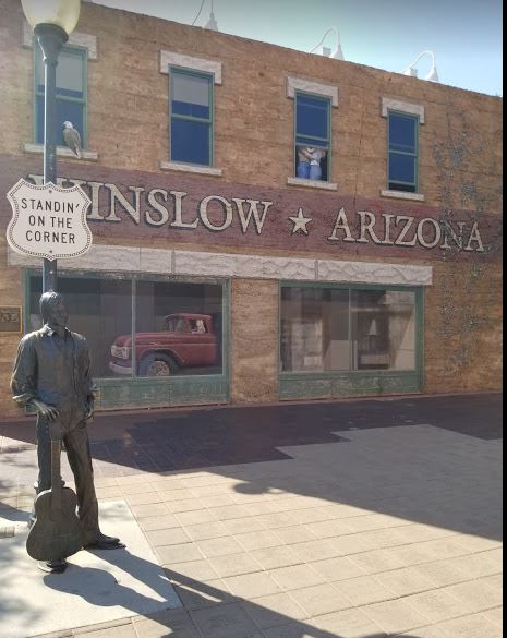
Final official Route 66 stop for us was a perfect ending to our nostalgic journey – Winslow, AZ – where some enterprising person decided to take full advantage of the Eagles song, Take it Easy, and created the “Standin’ on a Corner in Winslow Arizona”. 


How they determined exactly which corner to use I don’t know, but each of the four corners has good photo bling.  They even parked a flatbed Ford in front ( you can see reflection in window in picture above).  Also, a huge kick-ass Route 66 painted in the middle of the four corners as our final goodbye .to Route 66 
We had planned to stop at the Meteor Crater, but given the cost of entry and the fact that everything but looking at the giant hole was closed down, we opted to save that for another day. 

With no particular plans on where to camp, we headed North hoping to get as close as possible to the Northern Rim of the Grand Canyon, tomorrow’s activity.  The bulk of the drive was through the Hopi Indian Reservation.  The road was empty and at one point I only counted passing about 7 cars in 15 minutes.  Averaging over 100 degrees, we wanted to get through the reservation as quickly as possible to find somewhere we could crash.  Our target town was Page, AZ, which appeared to be an entry point for anyone going to the North Rim or spending time on Lake Powell.  When we finally pulled into Page (it was still 100 degrees), I jokingly said – “Look a Hyatt” hoping we could hotel it rather than sweat to death.  As we pulled into the campground, which resembled a hot, dry, desert parking lot, I saw a sign for Hampton Inn and said – “There is a Hampton…”.  Damon told me to check availability and while I was researching, the Hilton app was not loading, so I went to Travelocity and lo and behold, when scrolling through hotels, there was  a listing for a Hyatt in Page.  It didn’t take much convincing and within 3 minutes I had booked a room using points and within 5 minutes we were in air conditioning in the brand new hotel with our upgraded canyon facing room.

We had a quick shower and went to dinner at a huge outdoor BBQ place we had passed on the way into town.  So far, I’m okay with this roughing it business!!!  Another blissful and cool night of sleep followed by another shower (got to take advantage) and off we went.

The second part of our journey begins tomorrow as we spend the next few days hiking in the remote parks - primary goal being the exploration of slot canyons in Utah.  More to come.