Last night was a chilly one, but in a good way – I got to snuggle in my Sherpa blanket and stay in bed until 7am. As the sun came up, the view from our tent was, once again, just gorgeous.
 |
| View out the back from inside the tent |
Side note: Damon is a big fan of off-road camping; he
has a bunch of maps that tell us which public lands allow camping, basically
anywhere. While they are typically
“campsites” and often have some type of fire pit, that is about the extent of
the luxury. Everything you need, you
bring. On the plus side, there is NO ONE
around and the views can be extraordinary if you find the right spot. Oh, and they are completely free!
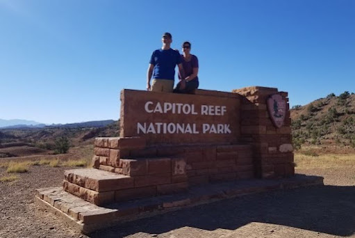
We had a leisurely morning, made breakfast, and rolled out of camp around 8:30 to explore Capitol Reef National Park.
Capitol Reef is definitely a lesser known of
the major National Parks in the area, but the benefits include very few people
and some of the most spectacular views I’ve ever seen – and we have hit nearly
every National Park in the area, some multiple times. Capitol Reef is all about towering red rock
cliffs, the brightest blue sky you’ve ever seen, and green shrubs and scrub for
added color.
Our first hike was going to be the Cassidy Arch trail, which is located on another designated scenic road. We found the trail head and quickly dropped into the wash.
We wanted an easy hike day, and this was a
3.1 mile round trip hike. The wash
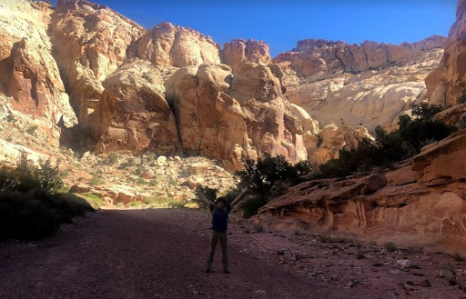
traversed a canyon that was breathtakingly gorgeous. The canyon walls had to be 300+ feet tall and
ranged from whites to reds and everything in between. I'm the little purple dot in the middle for scale
We were so busy looking at the scenery that
we completely missed the trail cut-off for the Cassidy Arch, which we realized
about 1.5 miles in. We talked to a
family and figured out we were on the Grand Wash trail and not the Arch
trail. The Grand Wash trail also had a
start point at the opposite end and it was about 3 miles from one end to
another (or 6 round trip).
 |
| Obligatory jumping picture |
The canyon we were in was fantastic, so we decided to keep
going; one aspect of canyons that we see everywhere is all of the holes in the
canyon walls – they are very common in Capitol Reef and are called “Solution
Cavities” or honeycomb weathering, caused by wind, water and ice that basically
erode softer areas of the sandstone leaving the harder portions intact.
We entered “the narrows” where the walls, still towering
above us, closed in. Not to the level of
a slot canyon, but happily for us, enough to provide a tremendous amount of
shade for most of the hike. At one point
we happened upon a national park services guy who was staring up the canyon
wall and taking pictures. We stopped to
chat (of course) and found out that he was identifying new historical
graffiti. Funny twist – if someone
carves their name into a canyon wall today, they are fined $300. If someone carved their name into the canyon
a long time ago, it is preserved as a historical artifact. This guy thought the “graffiti” was probably
from the 1910-1920’s given the look of the handwriting; thus, it was being
marked and preserved.
 |
| Date estimate based on seraphs in lettering |
We made it almost to the opposite end of the Wash, but hit an unshaded stretch and turned back. Overall, one of the most beautiful hikes I’ve ever been on, which ironically, was completely unplanned. On our way back, we found the turn-out for the Cassidy Arch (named after Butch Cassidy because he had a hideout in the Grand Wash and the Arch was a guide to finding his hideout), which was another 3 miles round trip plus a 1,000-foot elevation gain in mid-day, full sun. No thanks. We finished our hike, found a viewpoint for the arch, thanked the lord we hadn’t hiked up it when we saw how high it was, and continued to our next hike.
 |
| Cassidy Arch is the little black dot at the top/middle |
We got to the end of the scenic road and then went further into another canyon, about 2 miles on a twisty unpaved road, ultimately getting to another car park. There was a short hike here called the Pioneer Register, a roughly 2 mile out and back hike to see more “historical graffiti” – the okay kind. The canyon walk was nice and we saw some petroglyphs, but the big payoff was several sections of exceptionally smooth canyon wall where people from the 1800’s on carved or painted their names on the rock. One in particular - we have no idea how they actually got to the section of rock to carve their names.
 |
| Names carved about 20' below cliff top |
 |
| Names blown up |
We saw a lot dated late 1800’s and early 1900’s, but they were also carved over other stuff that had to be even older. Some of the carvings looked like bullet holes and others were so high up, we had no clue how someone could carve their names unless dangling 20-30’ off the top of a cliff. Of course, there are always some morons who feel the need to add current carvings, thus requiring the park to put in security cameras to preserve history.
 |
| Bullet holes upper left? |
We are trying to limit ourselves to 2 hikes per day and no
more than 5-8 miles – mostly because it is just too hot to hike much longer
into the day. We headed back up the
scenic road and encountered a lot of interesting wildlife – a reindeer and a
random free-range cow just walking up the middle of the road all by
itself.
I can’t say enough about the scenery in Capitol Reef – it is
hand’s down some of the best in Utah. I
couldn’t stop taking pictures – the sky is insanely blue every single day; and
the backdrop with red rocks is just amazing.
Sadly, we only had one day allocated to Capitol Reef as we are still on
a mission to hike a great slot canyon.
We always wondered how the government determined where to put National
Park borders. I think that question was
answered as we left the designated park because almost immediately, the scenery
changed, and we entered the weirdest landscape ever.
We went from gorgeous red rocks to this bizarre totally desolate landscape that was almost creepy to drive through. Rocks and landscape turned very gray with almost nothing of color visible. Plus, it was averaging about 97 degrees – desert heat makes everything worse.
Eventually we came to a small town called
Hanksville, giving us about 5 minutes of cell service to try to map out camping
options. To give you an idea of how
strange the landscape was, Damon realized that we were close to the Mars Desert
Research Station – a place where they could simulate life on Mars. Of course, we had to go visit it.
Another 3-mile off road adventure – where we truly felt like we were on another planet.
And then in the middle of all of it we saw the Mars
habitat simulators. We couldn’t get too close, but it was interesting to see –
especially because I recently listened to a podcast called “The Habitat” that
followed a group living in a similar set up in Hawaii.
 |
| Habitat & Greenhouse |
Our final day (tomorrow) will be spent in an area near
Goblin Valley State Park, which is in the middle of no-mans-land. We took a chance and tried to find a place to
camp, but everything was very exposed, windy, and crazy hot. We went to Goblin Valley Park and they had one open
camping spot left. Despite the lure of
bathrooms and showers, we opted to try to find another BLM area to camp – one
gets spoiled with privacy, views, and silence.
Luckily, the park guy had told us of an area that had several BLM roads
that was close by, so we tried that.
We found an amazing spot that I dubbed the “HooDoo Hollow”. It was completely shaded by the time we got there with an arc of tall hoodoos that blocked wind and gave us some reprieve from the sun.
 |
| Not a great picture, but we had a half circle arc of hoodoos surrounding us |
We set up
camp, made dinner, stared at nature, stared at nature some more, had a close
call with a low flying bat (just the one) and then went up to the tent where we
stared at stars. There have been a few
times that I’ve been in a secluded and dark enough spot to be able to see the
Milky Way. This was one of those
times. I have not so awesome vision and even
without my contacts in, I could see the Milky Way with my naked eye. I put on glasses and the stars were insane. Billions and billions and the Milky Way was
so defined you could trace it across the whole sky. Even though it was still hot outside, the
temps do tend to cool down overnight, so sleep was not bad at all. Last night in a tent!


No comments:
Post a Comment